spacer
No current alerts for: "Greater London (UK258)".
METRIC | IMPERIAL
Updated: 01/01/2026 @ 18:56   (0 sec ago)
Temperature Current Conditions Forecast / Storm Prediction
Currently Outside: Colder 0.1°C than last hour.

5.2°C

---
High Today
6.6°C
13:17
Low Today
0.8°C
00:31
Yest High
4.6°C
13:09
Yest Low
0.5°C
08:09
Sta* High
14.5°C
2022
Sta* Low
0.2°C
2020
* This Station's Records Since 1/2020
Dry, A few clouds Dry, A few clouds

Wind from WNW Wind:  WNW
1.0

Gusting to:
3.9 km/h
Current Rain Rain:
0.0 mm
Fire Weather Index: MINIMAL Current FWI:4
Fire Danger:
0.6 of 232
Tonight
Partly Cloudy
Partly Cloudy
Tomorrow
Partly Cloudy
Partly Cloudy
Tomorrow night
Clear
Clear
2°C 4°C -2°C

Click here for full Forecast
SPC Activity Map
Dew Point Liquid Precipitation Wind Speed Sun/Moon
Current: Decreased 0.5°C since last hour. 1.3°C
Last Hour: Decreased 0.5°C since last hour. -0.5°C
High 14:18: 2.6°C
Low 00:31: -1.4°C
Record High: 22.2°C on
12-Aug-2024
Record Low: -16.3°C on
4-Aug-2024
Wetbulb: 3.7°C
Today: 0.00 mm
Yesterday: 0.00 mm
Last 7 Days: 0.00 mm
Jan Rain: 0.00 mm
Jan to Date
  Avg:10
3.64 mm
Jan to Date
  Diff from Avg:10
Under 3.64 mm for the month 3.64 mm
Jan Avg: 60.40 mm
Diff from Avg: Under 60.4 mm for the month 60.40 mm
Season:1 0.0 mm
YTD
  Avg:11
3.64 mm
YTD
  Diff from Avg:11
Under 3.64 mm for the year 3.64 mm
Last Rain
Time/Date:
21-Dec-2025
at 23:00
0 rain days in 2026
0 days in January
9 days since last rain
Current: WNW  1.0 km/h
1Hr Average: 4.4 km/h
Wind Run: 79.77 km
Wind Gust
Current: 3.9 km/h
Today: 37.0 km/h 13:52
Month: 36.7 km/h 1-Jan
Year: 36.7 km/h 1-Jan
Record Gust: 74.0 km/h
7-Dec-2024
Sunlight:
7 h 54 m 53 s
of Sunlight Yesterday
7 h 55 m 58 s
of Sunlight Today
Which is
1 min 5 sec longer than
yesterday
7 h 57 m 12 s
of Sunlight Tomorrow
(Noon ?>) graph (Midnight
Legend

Waxing Gibbous
Waxing Gibbous, 12 days, 17 hours, 13 minutes in cycle
96%
Illuminated
Humidity Barometer
Current: Decreased 2% since last hour. 76%
Last Hour: Decreased 2% since last hour. 2%
High 00:00: 85%
Low 13:17: 74%
Record High: 100%
27-Oct-2024
Record Low: 32%
25-Aug-2025
Current: Falling 0.2  hPa/hr 1006.1 hPa
Last Hour: Steady
High 00:00: 1019.5
Low 18:20: 1006.1
Record High: 1044.6 hPa
6-Feb-2025
Record Low: 971.3 hPa
6-Jan-2025
Heating Degree Days Tide Wind Chill
Today: 12.5
Jan: 12.5
2026 to Date: 12.5
Cooling Degree Days
2026 to Date: 0.0

16 hours, 19 minutes to high tide at
11:15 AM GMT


Current: 4.8°C
Low 01:11: -3.0°C
Yesterday: -3.1°C
Record: -8.4°C
18-Jan-2024
UV Summary/Forecast Solar Summary
High Today:   0.0 @ 00:00
Jan-02

0.4
Jan-03

0.4
Jan-04

0.4
High Today:  
186 W/m2 @ 11:14
Sun Hours Today:
00:33
   This Month: 00:33 Hrs
Rise: 08:05  Set: 16:01
Almanac Irrigation Index5 Station All Time Records Cloud Level
Currently: Evening
YTD Avg Temp: 3.5°C
Sunrise: 08:05
Sunset: 16:01
Moonrise: 13:27
Moonset: 06:20
Full Moon: 03-Jan-2026
New Moon: 19:53 UTC
18-Jan-2026
Updated at Midnight
Current ET: 0.40 mm
7-Days Rain: 0.00 mm
7-Days ET: 2.40 mm
7-Day:  2.4 mm water in deficit of what evaporated in last 7 days. 2.4 mm
January: No Change 0 mm
HIGHS: LOWS:
33.1°C
12-Aug-2024
-4.6°C
18-Jan-2024
Daytime Records
  31.0°C°C
12-Aug-2024
  -0.8°C°C
10-Jan-2025
Nitetime Records
  23.1°C°C
20-Jul-2024
  -2.3°C°C
11-Jan-2025
ICN:1 | S3C2:2 | Ajax 3.xx
ISS:Ok | CON:4.8 | RCP:99%
1 Rain season: Jan 1st to Dec 31st.   4 Updated at Noon Central Time.   5 Estimated amount of water needed to replace the water used by plants and evaporation from the past week. (Negative numbers mean amount of water needed, positive numbers mean excess water is present).   10 Historical average only to day 1 of just the month of January for this station since 2021.   11 Historical average rain this season to day 1 of January for this station since 2021.
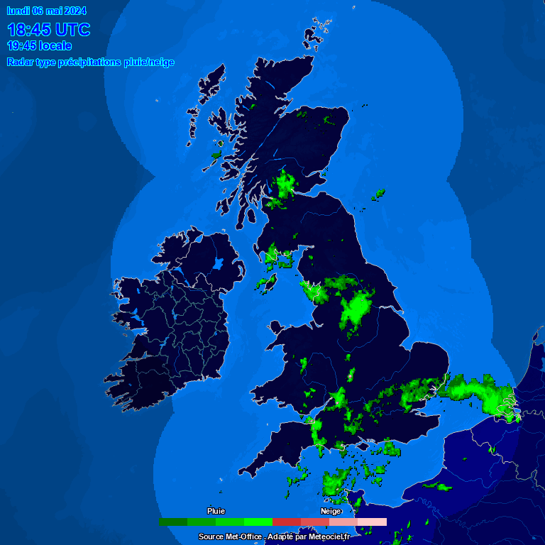
 WU/TWC Weather Forecast  -   Outlook Tonight & Tomorrow
Tonight
Partly Cloudy
Partly Cloudy
2°C
WU/TWC forecast: Mostly clear early followed by cloudy skies overnight. Low 2C. Winds WNW at 15 to 25 km/h.
WXSIM forecast: Fair in the evening, becoming mostly cloudy after midnight. Low 2°. Wind chill ranging from -2 to 4. Wind northwest around 16 kph, gusting to 28 kph.
Tomorrow
Partly Cloudy
Partly Cloudy
4°C
WU/TWC forecast: Partly cloudy skies. High 4C. Winds WNW at 15 to 25 km/h.
WXSIM forecast: Partly to mostly sunny in the morning, becoming sunny in the afternoon. High 5°. Wind chill around 0. Wind northwest around 15 kph, gusting to 29 kph.
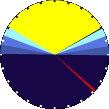
 WU/TWC Short Term Weather Forecast
Tomorrow night
Clear
Clear
Saturday
Mostly Sunny
Mostly Sunny
Saturday night
Mostly Clear
Mostly Clear
Sunday
Sunny
Sunny
Sunday night
Partly Cloudy
Partly Cloudy
Monday
Sunny
Sunny
Monday night
Clear
Clear
-2°C 3°C -3°C 3°C -3°C 2°C -5°C
ajax-dashboard6.php - Version 6.95h - 20-Feb-2023 - Script by: Scott of BurnsvilleWeatherLIVE.com
Now supported by Saratoga-weather.org Download